Before an autonomous mobile platform can plan trajectories, it must solve a fundamental spatial question: “Which regions of the local 3D volume are free versus occupied?"
The long-standing industry dispute between LiDAR Sensor Fusion and Pure Vision Occupancy Networks represents two contrasting engineering philosophies regarding hardware versus algorithmic leverage.
1. Comparing Spatial Perception Pipelines
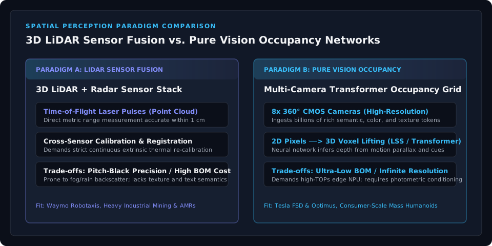
[LiDAR Sensor Fusion Pipeline]
Laser Emission ──> Time-of-Flight (ToF) ──> Sparse 3D Point Cloud ──> ICP Extrinsic Registration ──> Bounding Boxes

[Pure Vision Occupancy Pipeline]
8x Surround Cameras ──> Multi-View Feature Extraction (ViT) ──> 2D-to-3D Transformer Lifting ──> Dense 3D Voxel Occupancy
2. Technical Specification & Operational Matrix
| Engineering Dimension | 3D LiDAR + Radar Sensor Fusion | Multi-Camera Pure Vision Occupancy |
|---|---|---|
| Ranging Physics | Time-of-Flight (Direct speed-of-light metric timing) | Optical parallax, motion parallax & geometric depth priors |
| Distance Measurement Accuracy | Direct error < 1~3 cm (Extremely precise) | Relative error |
| Sensor BOM Unit Cost | High ($1,500 to $8,000 per platform) | Ultra-Low ($150 to $400 for 8x CMOS camera modules) |
| Nocturnal Darkness Performance | Flawless (Active self-illuminating laser) | Requires active illumination or high dynamic range (HDR) tuning |
| Adverse Weather (Snow/Fog/Rain) | Degrades (Laser pulses scatter off airborne droplets) | Matches human optical driving limits under wiper clearing |
| Semantic & Texture Resolution | Minimal (Reflectance intensity points only) | Superior (Reads road signs, lane markings, brake lights) |
| Mechanical Durability | Moving prisms or high thermal density emitters | Solid-state automotive CMOS sensors (High MTBF) |
| Edge Compute Footprint | Moderate (Sparse point processing) | Extremely High (Demands high-TOPS dense voxel decoding) |
3. Algorithmic Breakthrough: 2D-to-3D Lifting via Transformers
Pure vision historically struggled with scale ambiguity. The breakthrough that elevated cameras to spatial parity with LiDAR was the advent of Lift-Splat-Shoot (LSS) and Spatiotemporal Deformable Cross-Attention:
[Camera 2D Image Coordinates (u, v)]
            │
            ▼ Projects viewing frustums conditioned on categorical depth probabilities
[Virtual 3D Frustum Voxel Space]
            │
            ▼ Cross-attention across cameras & temporal history
[Ego-Centric 3D Voxel Occupancy Grid (x, y, z)]
Discretizing the local perimeter into small volumetric voxels (typically $10\text{cm} \times 10\text{cm} \times 10\text{cm}$), the network outputs an occupancy probability () alongside velocity flow vectors ().
Consequently, whether facing an unclassified fallen cargo crate, trailing rebar on a flatbed trailer, or loose debris, the planner treats the physical mass as an impassable obstacle without requiring prior supervised semantic categorization.
4. Market Allocation Across Industrial Verticals
- B2B Robotaxi Fleets (Waymo, Cruise): Where regulatory certification and zero-fail liability override hardware BOM concerns, operators maintain redundant multi-LiDAR and multi-radar arrays, prioritizing hardware safety margins over unit cost.
- Consumer Mass Humanoids & Volume EVs (Tesla Optimus, FSD): In high-volume consumer manufacturing targeting sub-$20k price points, bulky thousands-of-dollar LiDAR pods are commercially unviable. These platforms bet entirely on silicon scaling: pairing inexpensive CMOS optics with high-TOPS onboard NPUs.
- Indoor Logistics AMRs: Warehouses maintain controlled ambient lux levels and operate under strict ISO 3691-4 industrial safety mandates. Here, hybrid configurations pairing a single baseline 2D safety laser scanner with stereo depth cameras represent the standard economic sweet spot.
To calculate edge NPU memory bandwidth requirements when deploying real-time multi-camera vision foundation models, explore our interactive On-Device VLA VRAM Calculator.